 |
| Extinct volcanic formations / approaching Phoenix / June 2016 |
Whenever I travel, especially in a plane or in areas of natural interest, I am always in awe of the evidence of geological changes which I can see. Some geologic formations look nearly identical to our volcano remnants here in Hawai’i.
 |
| Dark upthrust formations / approaching Phoenix / June 2016 |
[As an aside, I know we are lucky to live in the state of Hawai’i. We are so close to one of the most spectacular locations to see vibrant geological changes - Hawai’i Island! That is why I love that island so much and devoted three blogs to it after a short trip there in February. [February 11, 2016: “Hawai`i Volcano active in so many ways!”, February 18, 2016: Our “growing” Earth (on Hawai`i Island), and February 25, 2016: Hawai`i Island as a great volcanic stage - of growth and drama!] Yet again Hawai’i Island is putting on a show as the lava flows to the ocean right at this time!
Park’s lava information ]
 |
| “Flat top” volcanic mountains / approaching Phoenix / June 2016 |
But my recent trip to Arizona and the East Coast allowed me to also see some geological wonders. The interesting thing is to run into many different forms of, or evidence for, volcanic activity all across the United States. Flying in a plane I saw this ancient volcanic formation with very evident erosion.
How is it that those Southwestern buttes and plateaus form from what seem to be former volcanoes? Is the geological formation so different because the form of erosion is most likely wind and not rain and ocean as here in Hawai’i’?
 |
| Erosion pathways / approaching Phoenix / June 2016 |
 |
| Winding waterway / approaching Phoenix / June 2016 |
While flying closer to Phoenix, I was fascinated by the barren areas that also gave some great visuals of waterways in the middle of what looks like flat desert and erosion tributaries.
Outside of Queen Creek, Arizona, a relative took us for a drive to see the surrounding mountains through Apache Junction. A prominent mountain area was Superstition Mountains. My research indicates these particular mountains are volcanic. (I thought the Superstition Mountains was just one mountain but I think it is a range.)
 |
| Superstition Mountains / beyond Apache Junction, AZ / June 2016 |
 |
| Yellow covered rocks / possibly Superstition Mountains / June 2016 |
 |
| Yellow covered hills / possibly Superstition Mountains / June 2016 |
As we drove beyond that area I believe we saw more evidence of volcanic activity in the hills and mountains. The mountains there were orange in color probably indicating the presence of iron as in the red rock of Hawai’i. I wondered if all the yellow coloring indicates sulfur as again is visible in active volcanic areas on Hawai’i Island. I cannot imagine the yellow coloring could be lichen covering the hills as it is so dry out there!
I believe the mountains through which we drove are the Mazatzal and Superstition Mountains. I had to use Wikipedia as I had a great deal of difficulty finding good sources for the Arizona mountainous areas. Maybe there is less information about the areas because the wilderness areas, with their barrenness and forbidding conditions, are still like the unexplored “wild west.”
As we drove further east, past Canyon Lake, there were layered formations that looked sedimentary. I think the identification of sedimentary formations is confirmed with this source.
 |
| sedimentary layers / possibly Mazatzal Mountains / June 2016 |
Then there were great examples of wind eroded mountains; while you look at the image you can just imagine the wind relentlessly forming the rounded mounds!
 |
| wind eroded mountains / possibly Mazatzal Mountains / June 2016 |
The desolate Southwestern United States was our “jumping off point” (from Hawai’i) to the diagonally opposite Northeastern United States.
 |
| waterway near Lincoln Woods / White Mountains, NH / June 2016 |
Needless to say there was quite a contrast between the two areas! Quite different forces of the Earth are at work here as evidenced by the very green landscapes and the ever present water features.
The lushness and wetness were created by the geologically recent retreating glaciers. One must look deeper, read signs, and know something about rocks to see the evidence of volcanic activity under the water “treated” surfaces.
 |
| water erosion / Sabbaday Falls, NH / June 2016 |
Of course, water erosion alone is exciting and breathtaking evidence of Earth’s changing surface!
 |
|
explanation of glacier and falls / Sabbaday Falls, NH / June 2016
|
 |
water erosion, up close / Sabbaday Falls, NH / June 2016
|
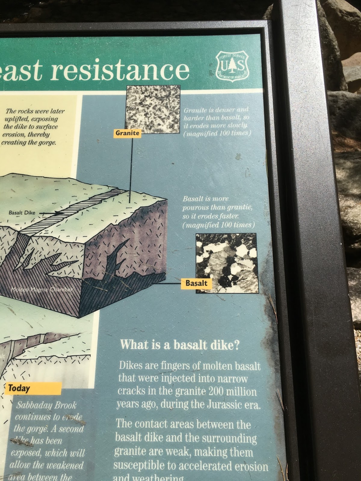
In addition, these Falls had a basalt dike which is a key indicator of volcanic activity; many of these are also found in Hawai’i.
 |
| basalt dike / Sabbaday Falls, NH / June 2016 |
 |
| explanation of basalt dike / Sabbaday Falls, NH / June 2016 |
This dike played a part in the current pathway of the falls.
 |
| basalt dike within the falls / Sabbaday Falls, NH / June 2016 |
 |
| diagram of falls formation / Sabbaday Falls, NH / June 2016 |
 |
| boiling pot-like formations / Sculptured Rocks, NH / June 2016 |
 |
| boiling pot-like formations / Sculptured Rocks, NH / June 2016 |
 |
| dramatic water erosion / Sculptured Rocks, NH / June 2016 |
The dramatic rounded erosion occurs in such a very short space and is very picturesque. The extensiveness is perhaps due to great amounts of rushing water for a longer time which would be expected in the glacially affected Northeast.
Sabbaday Falls also had a “pothole” near the base of the falls which may have been formed by water erosion of less dense rocks.
 |
pothole / Sabbaday Falls, NH / June 2016
|
Whenever you travel airways, pathways, and roadways, keep “watching out for nature” to see the wonders of how our Earth’s surface has changed in the past and continues to change.


No comments:
Post a Comment